


Marine Navigation Lite

Marine Navigation Lite의 설명
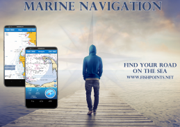
MARINE NAVIGATION AMERIGO
Find your road on the sea! GPS chartplotter for your boat.
Navigate with your favorite device everywhere in the world, transform your smartphone or tablet in a GPS navigator with offline map, perfect for sea, rivers and lakes, for boaters, fishermen and water sports.
This app is dedicated to the sea and the people who love and live it with passion.
WHY USE MARINE NAVIGATION?
Because it is easy to use, you need only activate app, you don't waist time for install instruments on your boat. It is cheap, you don't need to pay a lot of money for sea navigation. You can get route information. Save your money and time, you think only about the marine destination.
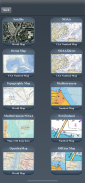
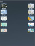
MAPS
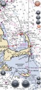
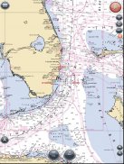
- NOAA Map
National Oceanic and Atmospheric Administration (NOAA), is a scientific agency focused on the conditions of the oceans and the atmosphere. Marine Navigation use NOAA RNC raster United States waters marine charts
- NOAA Mediterranean
National Oceanic and Atmospheric Administration (NOAA), Marine Navigation use NOAA RNC (Raster Navigational Charts) Mediterranean charts.
- Mediterranean Nautical Charts
- LINZ NewZealand
NZMariner is the product name of New Zealand's Official RNC (Raster Navigational Charts)
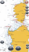
- Ocean Maps
Esri created and released a new, comprehensive map of the world’s oceans and coastal areas
- Topo Maps
This world topographic map (aka “the community basemap”) includes boundaries, cities, water features, physiographic features, parks, landmarks, transportation, and buildings.
- World Map
This map service presents satellite imagery for the world and high-resolution imagery for the United States and other areas around the world
- OpenSeaMap
more information on :http://www.fishpoints.net/mapsMAPS OFFLINE & MAPS CACHE - How Download offline map (http://youtu.be/MSTjDf-V9vI)
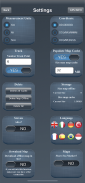
You can download maps in Marine Navigation Amerigo, you need select area on the maps, then download and save tile in the disk. You can navigate on preloaded maps without connection. You need to select the offlinemap on navigate view.
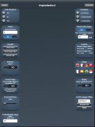
SYNC
You can share your WayPoints by the sync function to all your mobile devices, or use sync for yours archive of Points of interest.
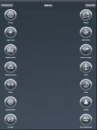
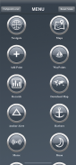
FEATURES
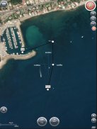
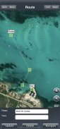
- Navigator GPS
- Interactive Map
- Sync
- Active Pointer
- Create/Manage/Delete POI
- Way Tracking
- Share Image
- Anchor Alert
- Code Morse
- Archive with 4000 SeaPorts
SOCIAL
Create your Yacht Club; share or import Points; Make the best marine navigation group.
-Login with Facebook Account
-Group (Public, Password, Invite)
-Create Your Group
-Archive Points
-Group Live Chat
-Group Share Image
-Admin Your Group
-Share WayPoints
-Import/Export Points
REFUND
You have 15 minutes from the time of download to return an application purchased on Google Play for a full refund.
After the 15 minute return period, don't worry, contact us oncontact@fishpoints.netHELP US
If you enjoy using Marine Navigation, would you mind taking a moment to rate it? It won't take more than a minute. Thanks for your support!
WARNING
Good seamanship requires the use of official charts. Marine Navigation is for use with other charts and cannot replace official charts. Use at your own risk.
VIDEO TUTORIAL
How create a new account (http://youtu.be/rUf4U4mQTwY)
How Download offline map (http://youtu.be/MSTjDf-V9vI)
LANGUAGE
-British
-Italiano
-Français
-Espagnol
REQUIRED
-Active GPS
LEARN MORE ABOUT FISHPOINTS:http://www.fishpoints.netand join us on Facebook, Twitter, Linkedin
Powered by Esri
Powered By NOAA
Powered By LINZ해양 항법 AMERIGO
바다에 길을 찾아라! 귀하의 보트 용 GPS 플로터.
세계 도처에있는 당신의 마음에 드는 장치를 탐색, 보텔, 어부, 바다 및 워터 스포츠에 대한 바다, 강, 호수 완벽한 오프라인지도와 GPS 탐색기에서 스마트 폰 또는 태블릿을 변환 할 수 있습니다.
이 응용 프로그램은 바다와 사랑하고 열정을 살고있는 사람들에게 최선을 다하고 있습니다.
왜 해양 탐색 기능을 사용?
사용하기 쉽기 때문에, 당신은 응용 프로그램을 활성화하기 만하면, 당신은 당신의 배에 장비를 설치를 위해 허리를 시간하지 않습니다. 그것은 저렴합니다, 당신은 바다 탐색을위한 많은 돈을 지불 할 필요가 없습니다. 당신은 경로 정보를 얻을 수 있습니다. 당신의 돈 및 시간을 절약, 당신은 해양 대상에 대한 유일한 생각합니다.
MAPS
- NOAA지도
국립 해양 및 대기 관리 (NOAA)은 해양과 대기의 조건에 초점을 맞춘 과학 기관입니다. 해양 탐색을 사용 NOAA RNC 래스터 미국 해역 해양 차트
- NOAA 지중해
국립 해양 대기 청 (NOAA), 해양 탐색을 사용 NOAA의 RNC (래스터 항해 차트) 지중해 차트.
- 지중해 해상 차트
- 린 츠 NEWZEALAND
NZMariner는 뉴질랜드의 공식 RNC의 제품 이름 (래스터 항해 차트)입니다
- 바다지도
ESRI는 창조 세계의 해양과 해안 지역의 새로운 포괄적 인지도를 발표
- 토포지도
이 세상 지형도 (일명 "사회베이스 맵") 경계 도시 물 기능, 지형 특징, 공원, 랜드 마크, 교통, 건물을 포함합니다.
- 세계지도
이지도 서비스는 전세계 미국 및 기타 영역에 대한 세계와 고해상도 이미지를위한 위성 영상을 제공
- OpenSeaMap
에 대한 자세한 정보 :http://www.fishpoints.net/mapsMAPS 오프라인 및지도 CACHE 방법 - 오프라인지도 (http://youtu.be/MSTjDf-V9vI)를다운로드
당신은 해양 탐색 칸테에서지도를 다운로드 할 수 있습니다, 당신은지도에 영역을 선택해야 다운로드 한 다음 디스크에 타일을 저장합니다. 당신은 연결없이 사전로드 된지도에 탐색 할 수 있습니다. 당신은보기를 탐색에 offlinemap를 선택해야합니다.
SYNC
당신은 모든 당신의 이동할 수있는 장치에 동기화 기능을하여 중간을 공유하거나 흥미 거리 너의 아카이브 동기화를 사용할 수 있습니다.
특징
- 네비게이터 GPS
- 상호 작용지도
- 동기화
- 액티브 포인터
- 생성 / 관리 / POI 삭제
- 웨이 추적
- 공유 이미지
- 앵커 경고
- 코드 모스
- 4000 항구와 아카이브
사회
귀하의 요트 클럽을 만들, 공유 또는 수입 거리; 최고의 해양 탐색 그룹을 확인합니다.
페이스 북 계정 - 로그인
- 그룹 (공공, 암호 초대)
당신의 그룹을 만들기
아카이브 포인트
그룹 라이브 채팅
- 그룹 공유 이미지
- 관리자 사용자 그룹
- 공유 중간
-Import/Export 포인트
환불
당신은 전액 환불에 대한 Google 플레이에 구입 한 응용 프로그램을 반환하는 다운로드의 시간에서 15 분 거리에 있습니다.
15 분의 반환 기간이 지난 후에, 걱정하지 마세요,contact@fishpoints.net에 저희에게 연락하십시오
미국 도움말
당신은 해양 탐색을 사용하여 즐길 수 있다면, 그것은 속도로 순간을 복용하면 될까요? 그것은 분 이상 걸릴하지 않습니다. 귀하의 지원을 주셔서 감사합니다!
경고
좋은 조종술 공식 차트를 사용해야합니다. 해양 탐색, 다른 차트와 함께 사용하고 공식 차트를 대체 할 수 없습니다. 자신의 위험에 사용합니다.
비디오 자습서
어떻게 새 계정 (http://youtu.be/rUf4U4mQTwY)를생성
오프라인지도 (http://youtu.be/MSTjDf-V9vI)를다운로드하는 방법
언어
- 영국
- 이탈리아어
- 프랑스어
- Espagnol
필수
- 액티브 GPS
FISHPOINTS에 대해 더 알아보기http://www.fishpoints.net와 페이스 북, 트위터, 링크드 인에 우리와 함께
ESRI에 의해 구동
NOAA에 의해 구동
린 츠에 의해 구동

Marine Navigation Lite - APK 정보
APK 버전: 6.1.10패키지: air.it.palaferri.fishpointsamerigoLiteMarine Navigation Lite의 최신 버전
다른 버전들


동일 카테고리의 앱


